3D Visualization in Agriculture
 When you stand at the elevators on the ground floor of the Agricultural Science and Industries Building you can look into the Land Analysis Lab. Work done here specializes in the use of GIS and related advanced geospatial / information system technologies for environmental assessment, agriculture, land management and planning. I always like to sneak peaks at the large maps and satellite images arrayed on walls and tables.
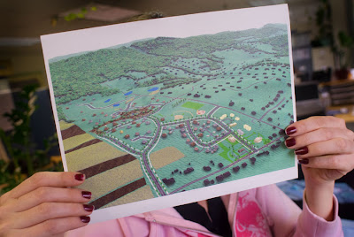
The above picture is a 3D visualization of 2D GIS data from a site in Centre County, Pennsylvania. I asked someone to take it off their bulletin board so I could make a quick shot. People already shudder when I arrive with the camera. No need to wear out my welcome unnecessarily.
The translation into a 3D model allows a person to interact with the data from a different point of reference, one that more closely models the physical reality of a space. Data for visualizations can come from a wide range of sources from satellites to readings from hand-held GPS devices in the field.
I’m always hoping I will see my house in one of these images. But then, that’s not why they are doing this work.


Comments
So, when you say "interact with the data from a different point of reference" this photo illustrates exactly what you mean? -:)) Very clever ! LOL!!
Harvey
I'm always amazed at how scientists creatively use ideas and technologies to address all sorts of things.
landconsultant: As I understand things the data sets can be very complex and the limiting factor is the computational power available to put things together.